
10 years
in business


Geo-Equipment Consultant
Delivering multi-disciplinary consulting services that pair high-precision GNSS/geodetic surveying with turnkey equipment rental, contracts, negotiation, and topographic studies for Cameroon’s infrastructure programs.
Empowering communities by transforming land knowledge into security, opportunity, and generational wealth.
Location
Yaoundé, Cameroon
Call
677 355 166659 796 533673 521 060
WhatsApp / Email
677 355 166 / 697 204 969+49 176 597 29775 / 690 462 359constrctr@restate.com
Our Story
Established in 2014 by Ayongaba Francois Agwenam, Geo-Equipment Consultant blends engineering precision with commercial insight. We provide geodetic GNSS programs, drone photogrammetry, cadastral services, and construction-equipment rentals so public works and private developments can advance on time and with confidence.
Credentials
Why partners choose us
Precision GNSS/geodetic control networks for large infrastructure.
Drone photogrammetry that unlocks 3D terrain analysis and cadastral clarity.
Negotiation, contracts, and general trade services that keep procurement compliant.
Contact
B.P. 916 Yaoundé — +237 677 355 166
Available 24/7 for online/offline consultations (Sat until 13:30)
10 years
in business
20-500 Million fcfa
turnover
1000
transactions
Mission
Est. 2014Lead Cameroon’s surveying, cadastral, and infrastructure programs with smart contracts, dependable geodesy, and responsive support that inspires trust across public and private stakeholders.
Presence
Yaoundé + RegionsA dedicated 17-person team of surveyors, engineers, negotiators, and administrators coordinates nationwide projects, ensuring compliance with government standards and topographic accuracy.
Corporate Bank Accounts:
Afriland First Bank: 06489961001
CCC Bank: 37211933402
Ecobank: 0222845401
Expert Team
A multi-disciplinary team of geodetic engineers, surveyors, negotiators, and project planners who keep public projects moving on time and on budget with culture, care, and accountability.

Founder & CEO
Civil engineer with ten years of experience leading multimillion-dollar infrastructure and land-development programs in Cameroon.

Deputy General Administrator
Geospatial project manager who coordinates GNSS campaigns, photogrammetry missions, and government partnerships.
Contact
Phone
677 355 166 / 659 796 533 / 673 521 060
677 355 166 / 697 204 969 / +49 176 597 29775 / 690 462 359
Our Services
From precision mapping and cadastral control to rental fleets and contracts, Geo-Equipment Consultant delivers end-to-end support for development, infrastructure, and land administration with Cameroonian expertise.
Premium project development, site selection studies, feasibility reports, and marketing support across residential, commercial, and mixed-use assets.
Explore →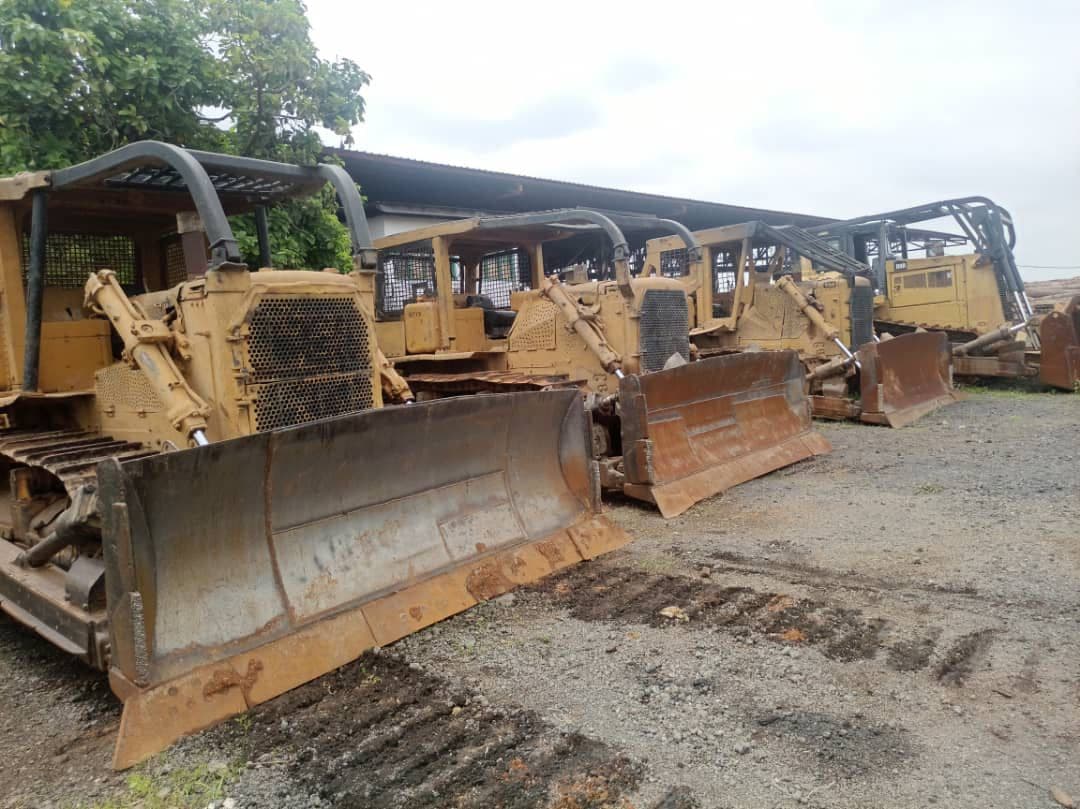
Heavy machinery rental (bulldozers, graders, compactors) plus acquisition strategies that blend short- and long-term pricing.
Explore →
Drafting, reviewing, and executing agreements that cover land acquisition, equipment procurement, and procurement compliance.
Explore →
Strategic negotiation support for real estate deals, government partnerships, and procurement of materials and services.
Explore →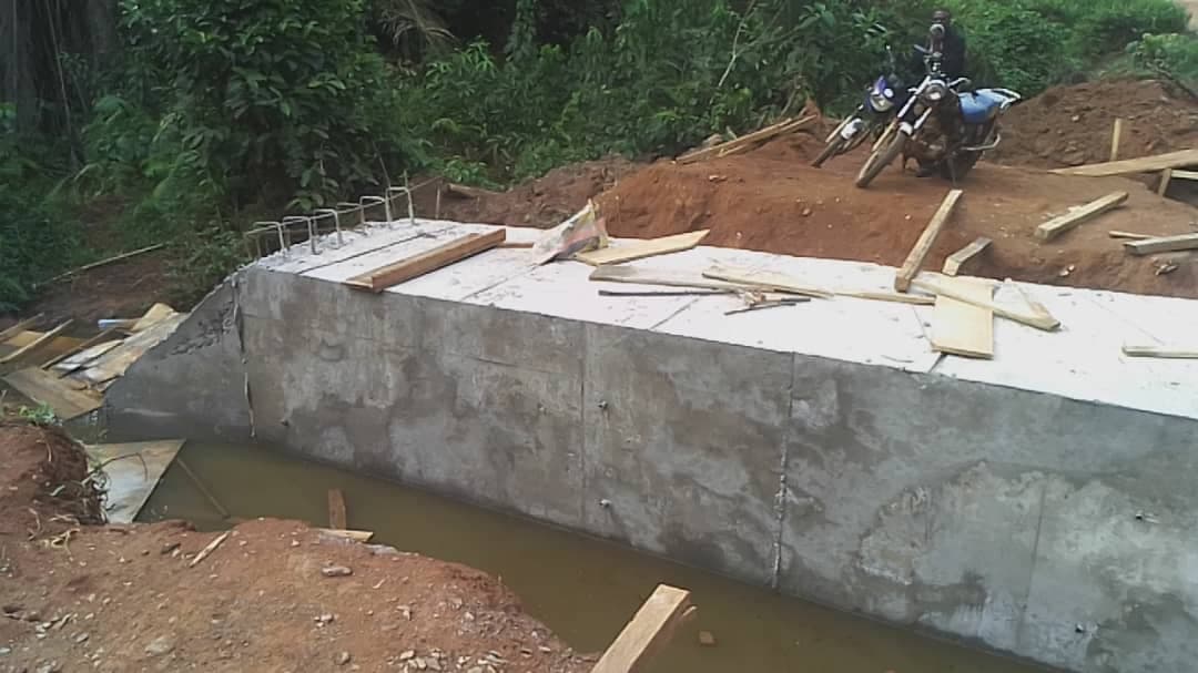
GNSS geodesy, drone photogrammetry, cadastral surveys, and terrain modeling for infrastructure and land administration.
Explore →Professional Profile
Highly skilled Geomatics and Geodetic Surveying professionals deliver GNSS/GPS precision, drone photogrammetry, engineering mapping, and cadastral services that support national infrastructure, land administration, aviation safety, and real estate planning.
10+ Years
Leading national infrastructure surveys
Drone + GNSS
Photogrammetry paired with precision control
International Reach
World Bank, airport, and regional programs
Decades of delivering geodesy, photogrammetry, and land administration programs for governments, banks, and developers.
Independent execution of complex geospatial and land-administration programs ensures transparency and strategic outcomes.
Public infrastructure modernization.
Land-use planning & regulation.
Aviation safety improvements.
Real estate development readiness.
Transparent compensation & expropriation support.
Digital mapping & smart land management.
UAV photogrammetry, GNSS control, and SfM processing deliver survey-grade orthomosaics and terrain intelligence.
Projects & Deliverables
Our portfolio spans GNSS geodetic control, tunneling, land clearing, and cart drafting for complex developments across Cameroon.

Projects & Deliverables
Measuring and mapping the position, dimensions, and boundaries of a parcel.
On-going
Projects & Deliverables
Detailed layout of a building floor with residential units and common areas.
On-goingProjects & Deliverables
Building underground passages used for transportation and mining.
On-going
Projects & Deliverables
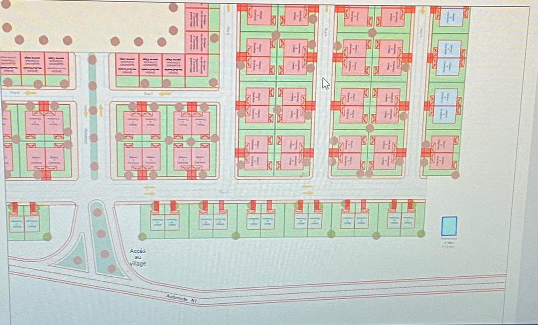
Large-scale layout of a residential development with housing units and open spaces.
On-going
Projects & Deliverables
Preparing sites by removing trees, stumps, brush, rocks, and obstacles.
On-going
Projects & Deliverables
Preparing road corridors by removing trees, stumps, brush, rocks, and obstacles.
On-going
Projects & Deliverables
Creating detailed drawings or maps from survey data for architects and engineers.
On-going
Projects & Deliverables
Residential layout planning for neighborhoods with shared amenities.
On-going
Projects & Deliverables
Interior floor layout with units, circulation, and common spaces.
On-goingContact
Tell us about your next project, site requirement, or equipment need. Our geomatics experts respond within one business day.
Office Hours
Mon–Fri: 08:30–17:30 | Sat: 08:30–13:30 (Yaoundé)
Phone
677355166 / 659796533 / 673521060
677355166 / 697204969 / +4917659729775 / 690462359
constrctr@restate.com